Egyptologists have assigned the beginning of writing in Egypt to the Naqada II period (3,600-3,000 BC). The new evidence presented in this paper indicates that the first tentative attempts at forming a sign system, from which the pharaonic script drew heavily, dates back to the beginnings of the Predynastic period (approx. 5,000 BC) (predating Naqada I (4,300-3,600 BC) by approx. 700 years). These roots of hieroglyphic writing were in parts, developed in the Western Desert of Egypt.
I.) Radiocarbon Datings from the “Giraffe Hunter & Nomadic Cattle-Pastoralist era”
A.) Results
Samples collected during my winter 2007/08 camel- expedition have recently been radiocarbon dated. These age determinations throw new light on the issue of the supposed age of the first attempts towards the formation of a pool of written signs which partly, formed the basis of the Pharaonic script.
Three datings are submitted here:
a.) decorated ostrich eggshells (2007/08-37b): BP 6,520 +/- 37 (Two Sigma Range: cal BC 5,557 – 5,378; probabilty 95,4%)
b.) ostrich eggshells (2007/08-39c): BP 6,244 +/- 35 (Two Sigma Range: cal BC 5,309 – 5,073; probability 95,4%)
c.) ostrich eggshells (2007/08-19): BP 6,492 +/- 35 (Two Sigma Range: cal BC 5,517 – 5,372; probability 95,4%)
Whilst the first two datings are from Biar Jaqub (Wilkinson´s 2nd Zerzura) a “lost oasis” about 60 kilometres southwest of Dakhla oasis, the third is from a site located a short distance away from a branch of the ancient Kufra Trail (KT), ie., about a third of the way from Dakhla oasis to the Gilf Kebir.
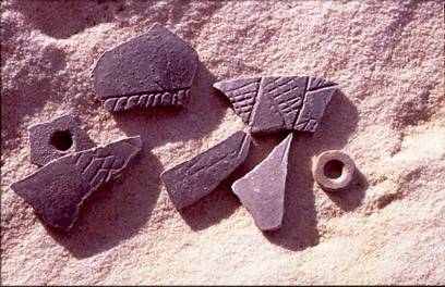
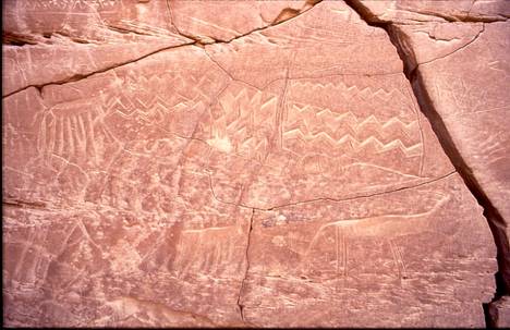
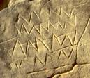
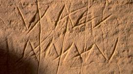
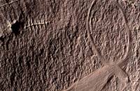
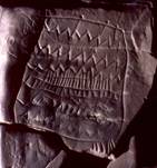
I had tentatively estimated the age of samples a.) + b.) to be around 5,500 years old (3,500 BC or slightly younger). This dating is predominantly based on the character of the motifs depicted on five ostrich egg fragments (picture 1), an exceptional find which, according to my judgment, exhibit a resemblance to the decorative art of Naqada II period (3,600-3,000 BC). However, the dating results above disabused me of such a notion.
picture !: fragments of decorative art on ostrich eggshells from a Giraffe Hunter
& Nomadic Cattle Pastoralist location in Biar Jaqub
Even if approx. 400 years for the reservoir age of ostrich eggshells found in the Nubian Sandstone environment of the Libyan desert are deducted from the datings presented above, the corrected average time spread spanning the period of cal BC 5,157-4,673 would not allow a link between the three samples and Naqada II. Irrespective of this outcome the following remarks will be based upon the corrected value.
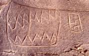
The (reservoir effect corrected) radiocarbon date throws new light on the issue of the supposed age of water mountain symbols (pictures 2 - 5) as well as on other “proto-hieroglyphs” found during my wanderings in Biar Jaqub.
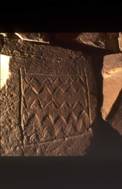
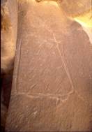
pictures 2 + 3: Two variants of water mountain ideograms
picture 4: water mountain ideogram into which the cartouche
of pharaoh Djedefre (4th dynasty) is inscribed
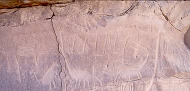
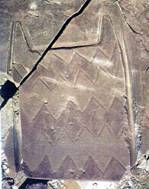
picture 5: Biar Jaqub water mountain ideograms and Neolithic fauna at water mountain outpost No. 10
The rock art of the Giraffe Hunters (picture 6) which lies in close proximity to the two sites where the eggshells were discovered, and which contains images of the mid-Holocene fauna as well as
a.) steatopygeous human figures (females)
b.) irrigated fields (and, possibly)
c.) pictograms of boats and crocodiles
d.) water mountain ideograms etc.
is, therefore, much older than previously assumed. (see earlier reports in www.carlo-bergmann.de) Henceforth, its age has to be fixed at about 1,000 years prior to Naqada II.
picture 6: self-portrait of the Giraffe Hunters of Biar Jaqub engaged in a hunt
B. Earlier assumptions about the age of the Biar Jaqub proto-hieroglyphs disproved
Neglecting the fact that the arrangements of some of the water mountain symbols in Biar Jaqub are apparently interrelated with Neolithic petroglyphs of giraffes as well as of other animals and that some of these depicted fauna are superimposed onto the water mountain symbols (pictures 7 + 8), K.P. Kuhlmann has put forward the proposition that the biliteral sign of the water mountain originates in the pharaonic period. (Kuhlmann, K. P.: Der „Wasserberg des Djedefre“ (Chufu 01/1) Ein Lagerplatz mit Expeditionsinschriften der 4. Dynastie im Raum der Oase Dachla. Mitteilungen des Deutschen Archäologischen Instituts Abteilung Kairo, Bd. 61 (2005) pp.271-275).
In the light of the radiocarbon datings presented in this paper Kuhlmann´s interpretation has lost its credibility. If water mountain symbols and other ideograms are regarded as proto-hieroglyphs, that is, as characters of a rudimentary “writing system” which most probably, was used for the (religious and/or environmental) description of the world as well as for communication purposes, then the collection of signs, which I have managed to detect in Biar Jaqub, and which constitutes parts of the origins of the ancient Egyptian script, is approximately 1,000 years older than so far assumed.
picture 7: Neolithic fauna superimposed on water mountain symbols at water mountain outpost No. 9
picture 8: Giraffe partly superimposed on water mountain symbol
C. Description of the places of discovery & conclusions
Their place of discovery reveals that the decorated ostrich eggshells are intimately embedded into a context containing diverse artefacts from the Giraffe Hunters & Nomadic Cattle-Pastoralists camp (a stone circle settlement of considerable size). The proximity of all these various remains including the rock art engraved in a semicircle around the fringes of the camp, indicates that all these features are directly linked. This extremely rare setting of remains allows well-founded analogies between age & style of the decoration of the ostrich eggshells and the rock art very close by. No doubt, those who incised the ostrich eggs with cross-hatched & herringbone bands and triangles are also the ones who adorned the nearby rock faces of their camp with images of giraffes, steatopygeous human figures and a water mountain symbol.
To the best of my knowledge, the discovery of these decorated ostrich eggshells allows access for the first time to dating of Western Desert (of Egypt) decorative art as well as to rock art including a cluster of proto-hieroglyphs created by Saharan Giraffe Hunters and Cattle Pastoralists long before the Pharaohs. (For a discussion of geometric art engraved on ostrich eggshells found at Capsian and Neolithic sites in Tunsia, Algeria and the Magreb see Belhouchet, L. Les gravures sur coquilles d´oeufs d´autruche en Afrique du Nord: interpretation des decors geometriques. SAHRA 19 (2008) pp. 77-84) On the basis of the above and with greater clarity than before, Biar Jaqub may now be revealed as one of the sites from where, starting from the beginning to the middle of the 5th millennium BC, the first tentative steps towards formation of a pool of written signs were taken, partly forming the basis of the much later Pharaonic script. Since the art on the egg shells (represented by three artistically well executed fragments) paves the way for identification of the ethnic group which created the decoration in question, the following may now be pointed out with more certainty.
D.) Mid-Holocene Cultural Units of the Dakhla region
1.) The reservoir age adjusted radiocarbon time spread (cal BC 5,157-4,673) presented above seems to refer to a period when the region of the Dakhla oasis was occupied by two cultural units known as the Bashendi unit (BU) (approximately dating to the “Middle Neolithic” 7,700-6,200 BP or even younger. See M.M.A. Mc.Donald: Neolithic cultural units and adaptions in the Dakhleh oasis in: C.S. Churcher, A.J. Mills (eds): Reports from the survey of the Dakhleh oasis. Western Desert of Egypt. 1977-1987. Oxford 1999, p. 122) and the Sheikh Muftah Unit (SU) (roughly dating from the middle of the 6th millennium BP to well past 5,000 BP. Ibidem p. 126) The BU “… might have survived beyond 5,500 BP …if the features it shares with the Sheikh Muftah and the Nile Valley Predynastic imply some contemporaneity with these latter units rather than, for instance, a simple ancestral relationship to them.” (ibidem) According to Warfe, the BU may be subdivided into the Bashendi A (dated 7,600-6,800 BP) and the Bashendi B (dated to 6,500-5,200 BP). “Besides being temporally separate, the units differ in subsistence strategies, patterns of adaption and in site location.” (A.R.Warfe: Interregional contacts with the Sudan: Ceramic evidence from the mid-Holocene period. In: G.E. Bowen; C.A. Hope (eds.) The oasis papers 3. Proceedings of the third international conference of the Dakhleh Oasis Project. Oxford 2004, p. 79) Thus, the radiocarbon dates presented above may be assigned to the Bashendi B cultural unit.
2.) It is generally accepted that the BU “… groups were not oasis dwellers, but rather the local version of the nomadic pastoralists whose campsites are scattered across the central and eastern Sahara.” (M.M.A. McDonald, op. cit. p. 127) Indeed, “… aspects of (their) material culture point to some degree of nomadism,… the scarcity of pottery, at a time when it had already been used in the area for thousands of years, conforms with the pattern for non-sedentary societies.” (ibidem) “Cattle (bones) were found at virtually all (their) sites…it seems likely that the Bashendi cattle were herded.” (ibidem, p. 120) Due to their nomadic lifestyle, the Bashendi, in all likelihood, possessed intimate knowledge of the desert, and therefore most of the rock art depicting typical African savanna animal motifs (such as giraffe, elephant, hippopotamus, zebra, buffalo, ostrich, gazelles and hartebeest) which has been discovered since the 1930s in the wider (desert) environs around Kharga and Dakhla oases, may tentatively be assigned to these BU groups. It is therefore not surprising that BU camps have occasionally been found in close proximity to such rock art sites.
3.) On the basis of
a.) the geometrically designed decoration depicted on the ostrich eggshells described above (picture 1)
b.) the dating obtained for these (as well as the undecorated) items
c.) the locations of their discovery
it is now certain that BU group individuals were responsible for producing the rock art in question. Moreover, apart from other “ideograms”, they also invented the water mountain “symbols”, consequently creating a pool of signs which, in later times, became part of the pharaonic script. The self-portraits of these BU groups, consisting of steotopygeous female figures and their slender male counterparts, are found at several sites in the desert. (pictures 9 + 10)
 .
. 
picture 9: steatopygeous female figures and their slender male counterparts
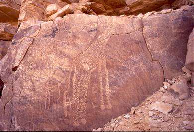
picture 10: steatopygeous figures amongst giraffes
E.) Spatial & temporal distribution of water mountain symbols and further implications
1.) I have discovered water mountain ideograms of much younger date in the vicinity of Farafra oasis. The symbols which, in my judgment, represent watering places (for cattle), are incorporated into a ceiling fresco belonging to the early Christian period. (picture 11) This proves that the water mountain ideogram developed at the beginning of the Predynastic period prevailed in the Western Desert oases until around 400 AD.
picture 11: image of a “water mountain” (on the right) being used
as a watering place for cattle (Farafra oasis, Early Christian period)
Kröpelin and Kuper observed such ideograms at Gala El Sheikh west of Dongola/Sudan. However, by adopting Kuhlmann´s wrong chronological projection without critical appraisal, the two authors arrive at vague and partly wrong conclusions. Quoting Kröpelin & Kuper directly: „... the isolated but identical presentation of the „water-ideograms“ more than 700 km south of the Dakhla area... bears implications for the question of early Egyptian relations with Sudanese Nubia. It suggests a line or a network of communication across the Eastern Sahara as late as the early third millennium BC. … The new evidence supports the scenario that even after 3,000 BC the Libyan Desert was not completely void of human activity. In its southern part, cattle keepers could survive as late as the second millennium BC… Apparently, the Egyptian Nile valley and the oases were connected with these regions and farther African destinations beyond by a network of donkey caravan routes crossing southern Egypt. Even if Egyptian activities from the Egyptian side were probably limited to occasional ventures such as the expeditions during Cheops´ reign or Harkhuf´s journeys, the “First World” along the Nile must have been a constant lure to the people at its peripheries.” (Kröpelin, S.; Kuper, R.: More corridors to Africa. Cripel 26 (2006-2007), pp. 225, 226)
2.) The type of periphery envisaged by Kröpelin & Kuper may not have existed around 5,000–4,500 BC. In addition, a network of north or south bound corridors (as the headline of Kuper´s & Kröpelin´s article is suggesting), along which the traffic of the desert rolled on, in all likelihood, did not exist either. Because (as Kröpelin & Kuper remark on p. 219) until about 5,000 BC, the landscape which is now a desert, consisted mainly of savannah and steppe fed by the steadily declining rainfalls of the Mid-Holocene Wet Phase. Due to such precipitation BU groups most probably were able to roam across this huge terrain without limitations just as well as they were able to squat or to settle wherever they found wildlife or appropriate grazing for their cattle as was also their custom. Such a scenario would easily explain the presence of water mountain-ideograms at Gala El Sheikh as well as the ubiquitous occurrence of images of steatopygeous human figures further north. (Apart from that Kuper & Kröpelin would have to prove that their find at Gala El Sheikh does not coincide either with early Christian activities in the Dongola reach, of which the ruins of Gala El Sheikh might have served as an outpost, or with activities & movements during Napatan times, of which another fortress-like ruin named Gala Abu Ahmed bears witness in the lower Wadi Howar.)
3.) The BU “… is a product of nomadic pastoralists who may have ranged well beyond the limits of Dakhleh…” (M.M.A. McDonald, op. cit. p. 128) BU camps in that region such as the Biar Jaqub site 2007/08-37b may be envisaged as “… annual refuge or aggregation points for mobile cattle-herders… Such localities “… would have become increasingly attractive … as the wider region began to dry out by the VI Millennium BP.” (ibidem) The stone slab structures of site 2007/08-37b suggest a move towards sedentism, although the “..Bashendi B groups from Dakhleh, for instance, appear to have been predominantly mobile in nature.” (A.R. Warfe, op. cit. p.86) In addition to and as a consequence of the steadily declining precipitation, BU groups would have been constrained by deteriorating environmental conditions, to turn their attention to water holes and wells much more than previously. This environmentally controlled “cognitive adaptation process” ultimately found its expression in the creation of analogous representations (signs and ideograms), of which the water mountain sign is the most prominent one. (For a more detailed elaboration of this transformation process see “Wilkinson´s zweites Zerzura” in www.carlo-bergmann.de)
4.) The existence of site 2007/08-19 shows that Kröpelin´s & Kuper´s “corridor theory” is not applicable for the period during which water mountain ideograms were originally created. This locality which was most probably permanently occupied, can be found more than 100 kilometres distant from Biar Jaqub. It contains a limited but comparable stock of rock art (including a representation of a steatypogeous individual), petrified bone fragments, an abundance of stone tools as well as two fine-tempered and thin-walled potsherds of Beshendi B provenance detected in the “kitchen area” of the settlement. The site is contemporaneous with sites 2007/08-37b + 39c. Its existence therefore, supports the idea that until around 4,600 BC Giraffe Hunters and Nomadic Cattle Pastoralists were still spread out over the whole Sahara in order to herd their cattle. (Note that in the wider environs of site 2007/08-19 three additional BU-camps of considerable size have been observed during a brief survey.)
5.) The new dating of the activities & presence of Giraffe Hunters and Nomadic Cattle Pastoralists in the Dakhla region and elsewhere (spatially) augments earlier assessments put forth by C. S. Churcher. (see C. S. Churcher: Holocene faunas of the Dakhleh oasis. In: Reports from the survey of the Dakhleh oases 1977-1987. op. cit. pp.133-151) concerning the reconstruction of the landscape and megafauna of the Dakhla oasis in BU times. During that period most probably, a similar landscape may be indicative of Biar Jaqub and, as found so far, of the wider surroundings of site 2007/08-19.
II. List of Biar Jaqub Proto-Hieroglyphs
A.) Basic signs
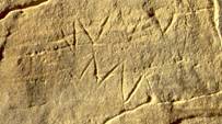
1.) Single horizontal zigzag line representing water (Over the lower right side of the zigzag line an ostrich has been superimposed.).
picture 12: “single water sign” at DWM
2.) (Horizontal) double zigzag line
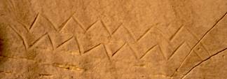
picture 13: “double water sign” found at water mountain outpost No. 9
3.) Stack of horizontal zigzag lines presumably representing deep water.
picture 14: stack of horizontal zigzag lines from a site near Biar Jaqub
picture 15: stack of horizontal zigzag lines partly superimposed
by a steatopygeous figure (water mountain outpost No. 2)
4.) Effaced pair of horizontal zigzag lines
picture 16: effaced pair of water lines picture 17: close up under sidelight conditions
I studied this depiction several times during visits to water mountain outpost No. 9. There is a marginal chance that four of the vertical scratches belong to a quadruped. In this case, the meaning of the superimposition of an animal on water lines is not clear. However, if an attempt was made to deliberately efface the water lines then these signs must have possessed an important meaning of some kind. (A meaningless “character” would perhaps have been destroyed by accident but it would not have been destroyed deliberately.) Thus, the depiction may be interpreted as “no water available any more”.
5.) Two diverging zigzag lines possibly meaning “outpouring of water”.
picture 18: “outpouring of water” from a site in
the surroundings of Biar Jaqub
6.) Singular horizontal crenellated line (representing flowing water) amongst Neolithic fauna.
picture 19: A crenellated line at water mountain outpost No. 0 representing flowing water
picture 20: close up under different lighting conditions
7.) Irrigated field (always in vertical position)
picture 21: irrigated field (at DWM)
B.) Basic signs of uncertain provenance/meaning
1.)
picture 22
2.)
picture 23
C.) Sign combinations
These are signs that were “derived” by deliberately combining basic characters. Sign combinations found so far focus on the importance of water and its availability.
1.) Double zigzag line attached to an irrigated field indicating an unspecified water source feeding into a field.
picture 24: field irrigated by an unspecified water source
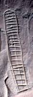
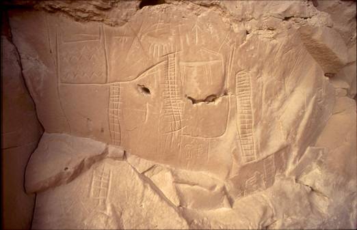
2.) Water mountain ideograms
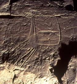
a.) “Ideal” water mountain ideogram indicating a hand dug well.
Generally, water mountain ideograms consist of two mountain signs added to the upper right and left corners of a rectangular “vat” which contains a number of water lines. (picture 25)
picture 25: ideal type of a water mountain ideogram
picture 26: label from the Tomb U-j reading “mountains of darkness” (my drawing)
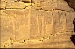
A label found by Dreyer in the Tomb U-j (circa 3.250 BC) at Abydos testifies to the use of mountain hieroglyphs in dynasty 0 times (picture 26). Davies and Friedman have interpreted the label´s inscription to mean “mountains of darkness” that is, “the Western Mountains” (or, my interpretation: the Western Desert. See Davies, V.; Friedman, R.: Egypt. London 2001, p. 37) The two signs in question are connected to each other, representing a silhouette of a mountain range as seen from a distance. In picture 25 the mountain signs are separated by a horizontal expanse. From the vantage point of someone spending a time in an area such as that between the hills of Biar Jaqub, the flat stretches of land would represent the layered (water-bearing) strata of playa in between chains of low hills. Presumably, wells were dug into this strata and the water mountain ideograms bear witness to the location of these wells.
On the occasion of Old Kindom visits to DWM, one can surmise that the two mountain signs belonging to the water mountain ideogram that bears Djedefre´s cartouche, were accentuated by additional strokes possibly indicating gullies descending from the elevations in question. (see picture 4)
b.) Variants of water mountain ideograms:
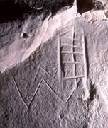
ba.) water mountain ideogram indicating a water hole (picture 3)
bb.) truncated water mountain ideogram indicating a shallow water hole (picture 27)
picture 27: truncated water mountain ideogram from water mountain outpost No. 9
bc.) Water mountain ideogram containing an irrigated field and an outlet/inlet channel for water (on the lower right; picture 28)
picture 28: watermountain with spout
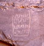
bd.) Water mountain ideogram with horizontal compartments containing zigzag or wavy lines (picture 29)
picture 29: water mountain ideogram with horizontal compartments (from DWM)
be.) Water mountain ideogram with vertical compartments (picture 30)
picture 30: water mountain ideogram with vertical compartments (from DWM)
bf.) Water mountain ideogram containing horizontal crenellated lines indicating a hollow in which water is flowing (picture 31)
picture 31: water mountain ideogram indicating flowing water (from water mountain outpost No. 9)
bg.) Water mountain ideogram containing both zigzag and crenellated lines indicating seasonal water flow in a well (picture 32)
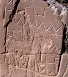
picture 32: water mountain ideogram containing zigzag and crenellated lines (from DWM)
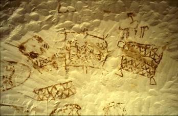
bh.) Ideograms representing water mountains, irrigation canals and irrigated fields amongst sparse Neolithic fauna. (picture 33) This “collage” which may represent the world´s oldest map or land register (The two pharaonic names found at this site are from a later period but related to the overall plan.) indicates the existence of “village” farming already during Bashendi Unit times.
picture 33: the world´s oldest land register (found at DWM)
III. Preliminary conclusions
1.) An abundance of stone circle settlements of considerable size densely clustered around “field temple” (but also found elsewhere in the palaeoasis; see earlier reports on www.carlo-bergmann.de), account for an unusually high population density in Biar Jaqub during the Giraffe Hunters & Nomadic Cattle Pastoralists phase. Two of the sites have been dated to the period of around cal. BC 5,157-4,673. (Most likely, the majority of the other sites belong to the roughly the same period.) This span of time coincides with the onset of an era during which “arid episodes associated with Atlantic cooling events were superimposed on a gradual weakening of the northern hemisphere monsoon system …(thereby causing) a general trend towards enhanced aridity throughout the northern hemisphere extra-tropics, punctuated by more abrupt changes.” (N.Brooks: Cultural responses to aridity in the Middle Holocene and increased social complexity. Quaternary International 151 (2006) p. 33) In this context, it is a widely held view that regions which “…were well vegetated became progressively more arid after the end of the 7th millennium BP, reaching a state similar to that existing today during the 5th millennium BP.” (ibidem, p. 30) It has been suggested that proto-historic societies such as that of the Giraffe Hunters of Biar Jaqub, may have responded to the gradual climatic and environmental desiccation of the Sahara through a combination of increased mobility and sedentism in favorable locations. (see F. Hole: Environmental instabilities and urban origins. Chiefdoms and early states in the Near East: The organizational dynamics of complexity. Monographs in World Archaeology 18. Prehistory Press 1994, p. 123) The small “villages”of the Biar Jaqub palaeoasis and its rock art may reflect the effects of such changes which for instance was manifested in:
a.) Hunting and gathering beginning to give way to cattle herding “… as cattle would have provided (their owners) with a more predictable source of nutrition in the form of milk, meat and blood than could be acquired from exploiting wild animals and plant species.” (N. Brooks, op. cit. p. 34) These two livelihood models would have coexisted for a long period of time.
b.) A gradual movement of human settlements from the desert towards environmental refuges (such as Biar Jaqub) where water remained available even during times of desiccation.
c.) Plant cultivation and animal husbandry (The spread of cattle keeping and -pastoralism appears to have been encouraged by climatic deterioration. See F. A. Hassan: Palaeoclimate, food and cultural change in Africa: an overview. In: F. A. Hassan: Droughts, food and culture. New York 2002, pp. 11-26)
d.) The exploitation of hand-dug wells at some of the Biar Jaqub playa sites (as evidenced in water mountain symbols found throughout the palaeoasis) dug in order to cope with water table levels that fell seasonally.
e.) “Village” farming (irrigation agriculture as evidenced in irrigated field symbols at Biar Jaqub) and pastoralism, with the latter involving in transhumance (large scale seasonal or year around movements in order to exploit remnant water and pasture).
f.) The emergence of a “cattle cult” (apparent in rock engravings throughout the Sahara).
g.) An increase in social complexity.
h.) The creation of a distinct set of signs and symbols (a process which may have been driven by a set of religious precepts as well as by the cognitive awareness of “…societies which were directly dependent on their immediate physical environment for their livelihoods and food security.” N. Brooks, op. cit. p.44 )
2.) Seemingly, in Biar Jaqub “…these developments did not necessarily depend on the prior emergence of an organizing elite…” (N. Brooks, op. cit. p.44). For instance, explicit representations of violence and authority (see R. Matthews: The archaeology of Mesopotamia: Theories and approaches. London 2003) are absent in the palaeoasis´ rock art of that time. That giraffe hunting was still a worthwhile profession until around cal BC 4,600 is attested by picture 6.
3.) The remarkable cluster of stone circle settlements about 100 km from Biar Jaqub also hints to the possible existence of quite a few habitable areas located
- outside the oases belt of the Western Desert (of Egypt) and
- beyond regions with elevation-induced rainfall capture
where sufficient, all year around supplies of surface water & grazing were available for big game as well as for the cattle pastoralists during the period in question.
4.) The discovery of proto-hieroglyphs in Biar Jaqub which have been dated to the beginnings of the Predynastic period, prove that ancient Egyptian “…writing developed from a more pictographic stage…” (Davies, V.; Friedman, R.: op. cit., p.36) roughly around 5,100 – 4,600 cal BC. Thus, these finds are likely to question the “…generally accepted theory that the invention of writing “…corresponds with the birth of the Egyptian state, and its growing administrative and bureaucratic needs.” (ibidem)
5.) If, as has been suspected in the past some “…of the earliest uses of … writing (in Egypt) were to record the receipt of tax, and donate the origins of commodities and their production date…” (ibidem) it may now be ascertained that the need to create a (limited) set of signs (mainly focussing on water and its supply) existed long before the pharaohs. The early signs helped the Giraffe Hunters and Cattle Pastoralists of Biar Jaqub to deal with challenges provoked by their steadily deteriorating environment. Thus, the primal origins of the Pharaonic script may have not been initiated by bureaucratic needs but have to be regarded as a human response to climatic change.
IV. Summary & Epilogue
Contrary to the prevailing opinion in Egyptology, it was not bureaucratic needs which facilitated the invention of a written language but rather, necessity per se (that is, the vital necessities of life itself). This event was triggered off in the Western Desert of Egypt by gradual degradation of environmental conditions which slowly began to take effect at the beginning of the Predynastic period, circa 5.000 BC.
Thus, the precursor writing of the Pharaonic script which had resulted as a consequence of an adaptation process to climatic change, had already come into existence in the Western Desert of Egypt more than 1000 years before tribes, societies and/or (unknown) bodies of people, had developed their bureaucratic procedures & structures.
FINIS
For additional information and amendments to this article see “Preliminary Report on the Results of Radiocarbon- and TL-datings (including roots of the Pharaonic script” published on this website.
Press responses:
The manuscript was offered to the following newspapers & magazines for publication; an endeavour without any success.
1.) National Geographic Magazine: Rejection. “The National Geographic Magazine does not accept unsolicited materials. Our editors meet regularly to discuss possible story ideas… It is extremely difficult to win a first assignment with the Geographic… Because there is a large investment behind each National Geographic article we are conservative in choosing writers, opting for those with well-established reputations… At this time, we have far more interested freelancers than we do assignments… appropriate queries can be sent to the editors of our Traveler and Adventure magazines.”
2.) National Geographic Germany: Forwarding the manuscript to National Geographic Magazine, USA
3.) New Scientist: No response
4.) Tagesspiegel, Berlin: Empty promises
5.) Antiquity: Rejection. „Thank you for sending us your article on the origins of the hieroglyphic script. I regret that it is not suitable for publication in Antiquity. All good wishes, Martin Carver.”
6.) GEO: Rejection
7.) DER SPIEGEL: No response
8.) SAHARA (Giancarlo Negro): “For us, like Sahara editors, there is a thorny problem about your possible publications. Like you know in the Sahara journal we have the “scientific advisors”, and Kuper is in the list. Consequence: we cannot publish your works.”
Sehlis 1/29/2009
Edwin van den Brink´s comments
Edwin van den Brink’s assessment of the Biar Jaqub (petroglyphic) proto-hieroglyphs concludes that the engravers were preoccupied with (the sparse availability of) water and with irrigation. He concedes that the “…unexpected early date is what it is: very early; stating that these glyphs predate the earliest texts (U-j) by a 1,000 years at least.” He continues that this “… is from a chronological point of view factual and therefore verifiable. However, this doesn’t establish –at least for me- a direct link between the petroglyphs and the Naqada IIIc earliest “texts”. It certainly does show that men were prone early on to record for practical purposes certain phenomena, but (mainly because of the few and invariable petroglyphic signs at issue) I don’t see how they could have influenced developments in Egyptian record keeping more than a millennium later… I do think you have a valid point in placing these petroglyphic records within the frame of very early desert society data transmission, but to try to establish a direct link between them and script “inventure” during early Naqada IIIc is stretching the present evidence too far.” (e-mail of 11/22/2008)
In response to Edwin van den Brinks valuable criticism I would like to:
1.) repeat that the Egyptologist K. P. Kuhlmann himself identified the Biar Jaqub water mountain petroglyphs etc. as hieroglyphic characters (see chapter B, “Earlier assumptions about the age of the Biar Jaqub proto-hieroglyphs disproved”) which the expert mistakenly dated to the 4th Dynasty.
2.) direct the reader’s attention to picture 12 of this article which contains an image of a water mountain datable to the Early Christian period. Notably, the water mountain “ideogram” is shown as a watering place for cattle in a context that is entirely pictorial.
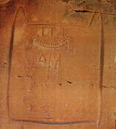
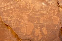
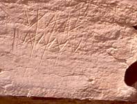
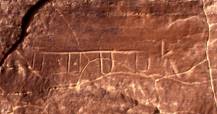
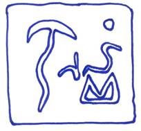
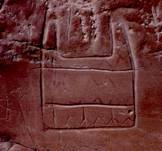
3.) remind the reader that yet another water mountain “ideogram” was found (in association with a Middle Kingdom inscription in the vicinity of Tineida, Dakhla oasis. picture 2)

picture 2: inscription of Meri including a water mountain in the vicinity of Tineida
(appositions in red by Egyptologist M. Herb)
The French team of archaeologists who detected the water mountain graffito near Tineida two years prior to my discovery of DWM, interpreted the sign as a water depot, cistern, well or water reservoir of which no equivalent in the established hieroglyphic vocabulary exists. (see my script “Wilkinson’s zweites Zerzura” and Bildergalerie, Bild 48 “inscription of Meri including a water mountain in the vicinity of Tineida” on this website) This is vivid proof that the utilization of water mountain “ideograms” had survived thousands of years until being incorporated into the Middle Kingdom graffito at the eastern outskirts of Dakhla oasis.
The discoveries itemized under 2 + 3 may not be regarded sufficient for establishing a direct link between (petroglyphic) proto-hieroglyphs and the Naqada IIIc earliest texts. However, for the time being they (together with the proto-hieroglyphs of Biar Jaqub), strongly indicate that an age old tradition in the use of such signs had existed for recording certain phenomena. These proto-hieroglyphs could only have survived if they were in continuous use in the culture, being passed down from one generation to the next. Such tradition must have also existed during the (more than) 1,700 year gap between the BU-b era and the Naqada IIIc period. Water mountain “ideograms”, zigzag- and crenellated lines, as well as irrigated field signs, found their way through the times. No doubt, these “characters” also found their way into the hieroglyphic script (zigzag lines constituting the letter “n” of the hieroglyphic alphabet). There is no reason to believe that somebody pulled them out of a hat in later periods. They were present during BU-b times and they were also in use in the Middle Kingdom period and even later.
If new archaeological sites datable to the period in question and containing elements of early proto-hieroglyphs (similar to those found in Biar Jaqub), are found, the gap between BU-b- and Naqada IIIc periods in particular, could be filled to the satisfaction of scholars. In this case, transformation and development from Biar Jaqub type proto-hieroglyphs to Naqada IIIc type early texts should become evident. At present, internal variations in the design of the water mountain “ideograms” (differentiation regarding their execution down to the last detail) strike the eye. This may indicate subtle distinctions in meaning, whereas phonetic meanings seem to be univocal.
Since the first attempt made by Gerhard Rohlfs in 1873/74 to explore the Libyan Desert west of the Egyptian oases it took roughly 125 years, until I discovered hitherto unknown “…petroglyphic records within the frame of very early desert society data transmission…” at W. J. Harding King´s stone temple (DWM; see Harding King, W.J.: Mysteries of the Libyan Desert (reprint). London 2003, pp. 145, 304) and in Biar Jaqub. May future research generate the evidence for establishing a link between the glyphs found at these two sites and the Naqada IIIc texts.
Carlo Bergmann
Sehlis 2/3/2009